A storm is brewing between India and Pakistan, but not in the usual theatre of action in the Kashmir sector, but in the faraway marshy lands of the Rann of Kutch, where the “Sir Creek” dispute has remained unresolved for the last 78 years.
Though the ‘Sir Creek’ dispute has not occupied the centre stage amidst the larger canvas of India-Pakistan relations, it is an important one for various factors. In fact, the ‘Sir Creek’ dispute has predated the existence of Pakistan.
While ‘Sir Creek’ does not dominate the imagination of Indians and Pakistanis like the Siachin Glacier, which happens to be the world’s highest battlefield, the outcome of the ‘Sir Creek’ dispute can have a far more detrimental effect on the two states’ future.
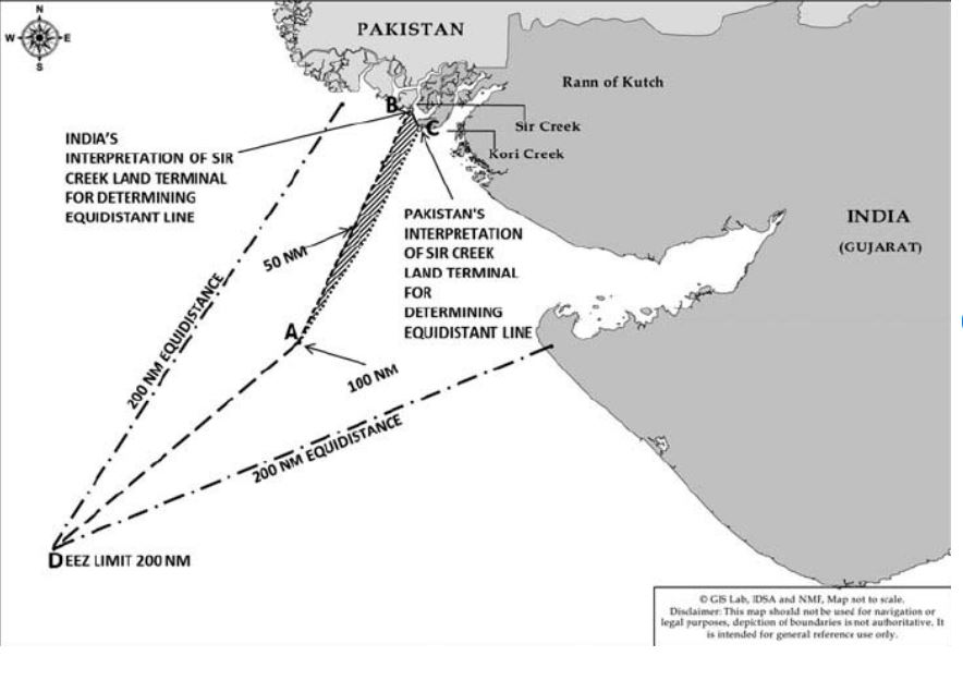
Even the slightest change in the maritime boundary in Sir Creek can result in the loss of hundreds of miles of Exclusive Economic Zone (EEZ) in the Arabian Sea. Additionally, this area is believed to be rich in hydrocarbons, and thus, any change in the maritime boundary can result in a loss of billions of dollars.
On October 2, India’s Defense Minister Rajnath Singh issued a stern warning to Pakistan over the Sir Creek region, reiterating India’s firm stance on the subject of its territorial integrity.
The minister said any Pakistani misadventure in this area would invite a severe Indian response, one capable of “changing both history and geography”.
“India has made several attempts to resolve the issue through dialogue, but Pakistan’s intentions remain unclear. The recent expansion of its military infrastructure near Sir Creek reveals these intentions.”
Pakistan should remember, Rajnath Singh warned, that one route to Karachi passes through the creek.
“If Pakistan dares to act in the Sir Creek sector, the reply will be so strong that it will change both history and geography. In 1965, the Indian Army showed courage by reaching Lahore, and in 2025, Pakistan must remember that the road to Karachi also passes through the Creek,” Singh said.
This was not an isolated statement.
On October 3, Indian Army chief General Upendra Dwivedi said that India’s western neighbour must stop state-sponsored terrorism or its historical and geographical existence will be in jeopardy.
“If Pakistan wants to maintain a place in world history and geography, it must stop state-sponsored terrorism. We will not show any restraint this time as we did during Operation Sindoor 1.0 and will go a step ahead if provoked again,” the Army chief said during his visit to the Bikaner Military Station to review the operational readiness of troops.
“It is possible that we will hit it so hard that Pakistan will be compelled to do a rethink, whether it wants a place in history and geography or not”.
General Dwivedi also told Indian troops to be prepared for another showdown with Pakistan.
“Please be fully prepared. God willing, you will get another opportunity very soon. All the best. Jai Hind,” he added.
Earlier, on October 2, Indian Air Force (IAF) Chief Air Chief Marshal Amar Preet Singh also told the soldiers to be prepared.
“We need to keep our thinking tabs on, stay ready for present and future wars, and adopt an integrated approach with all services and agencies,” he said.
The three back-to-back statements by the Defense Minister, the Chief of Army Staff, and the Air Chief Marshal within a 24-hour period have taken everyone by surprise.
Furthermore, the Indian military leadership is not known for issuing provocative statements like changing the geography and history of Pakistan.
The back-to-back, strongly worded statements are a clear indication that India has credible intelligence inputs about Pakistan preparing for some action in the Sir Creek region, and these statements were meant to warn Islamabad that any provocation will be duly responded to.
Multiple open source intelligence accounts are reporting that Pakistan is steadily boosting its military infrastructure in the Sir Creek region, raising concerns on the Indian side.
Notably, Prime Minister Narendera Modi had also visited the Sir Creek border outposts last year and met the Indian soldiers deployed there.
Went to one of the floating BOPs in the Creek area and shared sweets with our brave security personnel. pic.twitter.com/aZ6pE1eajK
— Narendra Modi (@narendramodi) October 31, 2024
In fact, not many people know, but while Pakistan has failed to gain any new territory in Kashmir since 1948, despite having fought three wars, in the Rann of Kutch region, Islamabad was actually successful in occupying India’s territory, which remains with Pakistan to date.
Furthermore, while people remember the 1965 India-Pakistan War for the action in the Kashmir theatre, the ‘Operation Gibraltar,’ not many know that much before Pakistan’s incursions in Jammu and Kashmir, India and Pakistan had fought pitched battles in the ‘Rann of Kutch’ region, which became the precursor to a much wider war by August 1965.
Where Is Sir Creek?
Sir Creek was initially named ‘Ban Ganga’ and got its present name after a British official. The creek is a 96-km tidal estuary along the India-Pakistan border, located between Gujarat in India and Sindh in Pakistan.
However, unlike the India-Pakistan International Border (IB) in Jammu, Punjab, Rajasthan, and Gujarat, the India-Pakistan border in Sir Creek is not demarcated and remains a disputed area.
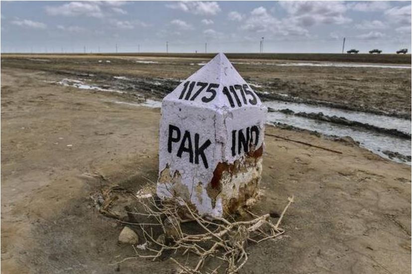
The mutual agreement between India and Pakistan defines the International Border from the Samba sector of Jammu up to Border Pillar No. 1175 in the Rann of Kutch.
Further to the north of the Samba sector in Jammu lies the Line of Control (LoC), running up to the Siachin Glacier.
South of the Border Pillar No. 1175 in the Rann of Kutch lies Sir Creek, where no formal agreement has been reached between the two nations. The Sir Creek runs till the Arabian Sea.
The ‘Sir Creek’ Dispute
The dispute traces its origins to the provisions of the 1914 Bombay government resolution, which sought to demarcate the area between its Sindh and Kutch divisions.
During that time, both the Sindh and Kutch regions were divisions of the Bombay Presidency, and both were part of the United British India.
A dispute arose between the Sindh and Kutch divisions in 1914 related to jurisdiction over the Sir Creek region. The 1914 Bombay government resolution sought to resolve this dispute by demarcating the boundary between the Sindh and Kutch divisions in the Sir Creek region.
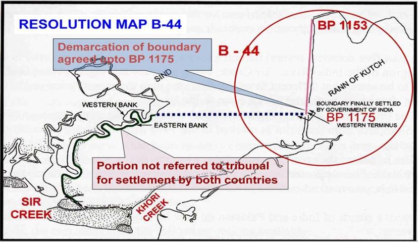
Paragraph 9 of the agreement states that the boundary lies “to the east of the Creek.” Pakistan has often cited this paragraph to support its claim that the India-Pakistan border in the Sir Creek region lies on the eastern bank of the water channel. In other words, the whole of Sir Creek belongs to Pakistan.
However, in 1914, both the Sindh and Kutch regions were divisions of the Bombay Presidency and were part of British India. After 1947, Sindh became part of Pakistan, while Kutch became part of India.
Thus, New Delhi claims that the boundary between India and Pakistan in this region needs to be settled in accordance with international principles of maritime law, specifically the Thalweg principle.
According to the Thalweg principle, a boundary can be fixed only in the middle of the navigable channel. Thus, according to India, the boundary between India and Pakistan in the Sir Creek region should be located in the middle of the Sir Creek.
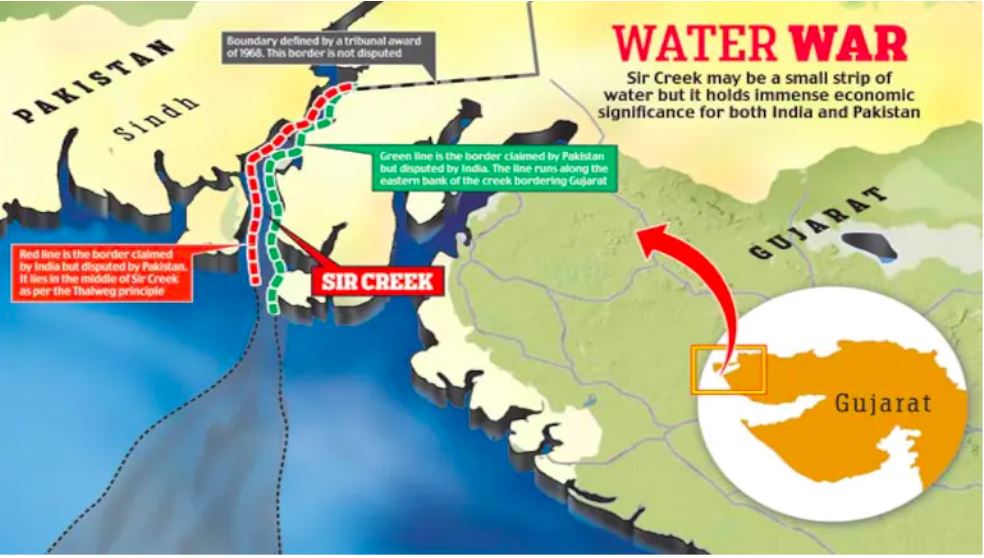
However, Pakistan disputes this, claiming that since Sir Creek is not navigable, the dispute could not be settled according to the Thalweg principle. However, India cites that the area remains navigable during high tide, and the boundary should be decided according to international norms.
Furthermore, in support of its claim, India cites Paragraph 10 of the 1914 Bombay government resolution, which states that Sir Creek is navigable “most of the year.”
During the India-Pakistan partition in 1947, while the International Border was demarcated in the northern part of the Rann of Kutch, with border pillar number 1175 serving as the last point of the demarcated international border, the area to the south of border pillar No. 1175, i.e., the Sir Creek region, was left unmarked.
In the 1950s, both countries attempted to resolve the Sir Creek issue, but their efforts were unsuccessful. The dispute flared into a military confrontation in 1965.
The 1965 War & Sir Creek
Contrary to popular memory, the 1965 India-Pakistan War did not start in Kashmir. Pakistan launched ‘Operation Gibraltar’ in Kashmir in August.
However, four months before that, Indian and Pakistani troops were already clashing in the Rann of Kutch when Pakistan launched ‘Operation Desert Hawk’. During the clashes, tanks and heavy artillery supported the soldiers, leaving scores dead on both sides.
By the end of April, Pakistan had occupied more than five miles of Indian territory in the Rann of Kutch.
After mediation by British Prime Minister Harold Wilson, a ceasefire agreement was signed between India and Pakistan on June 30, 1965. However, just three months after this ceasefire agreement, a more serious and wider conflict broke out between India and Pakistan in Kashmir.
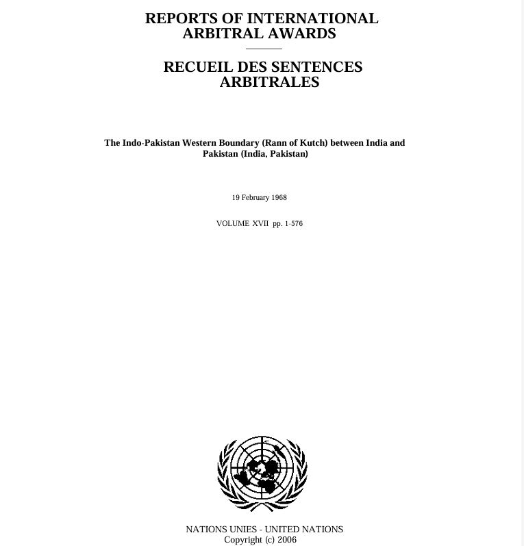
However, as decided in the ceasefire agreement of June 30, 1965, India and Pakistan agreed to submit their dispute to international arbitration.
The Indo-Pakistan Western Boundary Case Tribunal gave its award in 1968. It ceded nearly 90% of the Rann of Kutch to India; however, it awarded almost 350 square miles of territory (roughly 10% of the Rann of Kutch) to Pakistan, which included the Kanjarkot fort and adjacent tidal basins, as well as the Chhad Bet and the surrounding salt pans.
Thus, despite its military successes, India had to cede territory to Pakistan in the Rann of Kutch under international pressure.
However, even that tribunal left the dispute over the Sir Creek unresolved.
Additionally, it was in the Sir Creek region when, in 1999, just months after the Kargil conflict, the Indian Air Force (IAF) shot down a Breguet Atlantic maritime patrol aircraft of the Pakistan Naval Air Arm, killing 16 Pakistani officials.
Again, in 2007 and 2012, India and Pakistan attempted to resolve the Sir Creek issue, but the talks ultimately failed.
Now it seems that both countries are boosting military infrastructure in the region, and given the volatile situation between India and Pakistan, a possibility of a military confrontation can not be ruled out.
Why Sir Creek Matters?
Sir Creek is a desert most of the time. During Monsoons, it becomes a marshland.
However, the area is rich in fisheries. Still, the real economic value of this region may lie in its hydrocarbon resources.
Wetlands tend to be rich in oil reserves.
Furthermore, any change in the boundary of Sir Creek can result in the loss of hundreds of square miles of Exclusive Economic Zone (EEZ) in the Arabian Sea.
This part of the Arabian Sea is also believed to be rich in oil resources.
Therefore, while the Sir Creek might only be a marshland, any change in the boundary in this region could result in a loss of billions of dollars.
For now, India has issued a stern warning to Pakistan not to disturb the status quo.
However, given the tenuous peace between India and Pakistan since Operation Sindoor, it won’t be surprising if another conflict breaks out between the two countries in this region.
- Sumit Ahlawat has over a decade of experience in news media. He has worked with Press Trust of India, Times Now, Zee News, Economic Times, and Microsoft News. He holds a Master’s Degree in International Media and Modern History from the University of Sheffield, UK.
- VIEWS PERSONAL OF THE AUTHOR.
- He can be reached at ahlawat.sumit85 (at) gmail.com


