
Under the garb of conducting scientific tests in the Indian Ocean, Chinese vessels are surveying vast swathes of the Indian Ocean Region. The data gathered would be invaluable for the Chinese submarines seeking to navigate the shallow waters of Malacca Strait and through the East IOR, causing much consternation to India.
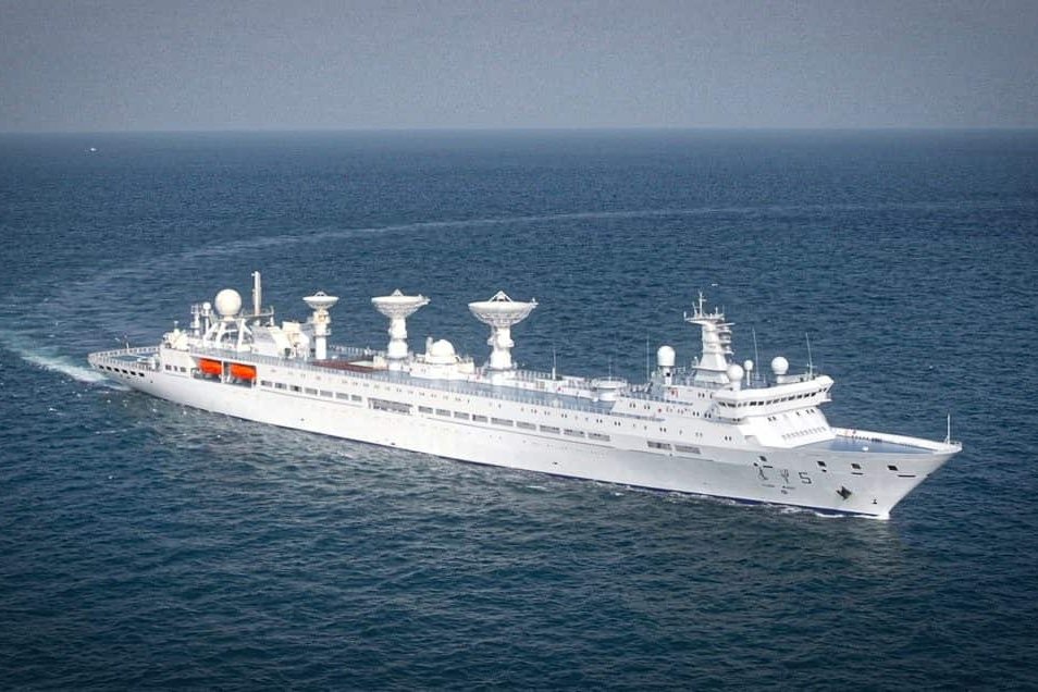
The latest in the series of Chinese Oceanographic survey vessels coming into the region for a three-month-long mission is Shi Yan 6, which has come to dock in the Hambantota Port in Sri Lanka, right under India’s nose. The Hambantota port has been run by the Chinese since 2017 when they took on a 99-year lease for US $1.12 billion, less than the US $1.4 billion Sri Lanka paid a Chinese firm to build it.
A Chinese broadcaster calls the Shi Yan 6 a “scientific research vessel.” Manned by a crew of 60, it can carry out oceanography, marine geology, and marine ecology experiments.
“The survey vessel can get data on seabed mapping, recording hydrological data to understand the profile of the undersea environment, subsea cable intelligence gathering, recording telemetry data of missile firings and so on,” Commodore Anil Jai Singh told the EurAsian Times.
China has termed its endeavors in the Indian Ocean as benign, a claim certainly not accepted by India. The capabilities that the Chinese Navy is pursuing in the region would help it to undertake a military mission in the region.
Indian External Affairs Minister S Jaishankar said on September 28, 2023, that in the past 20-25 years, there has been a steady increase in the Chinese naval presence in the Indian Ocean. “But there’s been a very sharp increase in the size of the Chinese Navy. So, when you have a very much bigger navy, that Navy is going to be visible in terms of its deployment somewhere,” he said, citing the examples of Chinese port-building in Gwadar in Pakistan and Hambantota in Sri Lanka.
The three Chinese-run ports in South Asia – Chittagong in Bangladesh, Hambantota in Sri Lanka, and Gwadar in Pakistan – are called a “triangle of death” encircling India.
Past Survey Missions By Chinese Vessels
Last year, Yuan Wang 5, one of China’s latest generation space-tracking ships – used to monitor satellite, rocket, and intercontinental ballistic missile launches, docked at Sri Lanka’s southernmost port at Hambantota. The Pentagon has maintained that Yuan Wang ships are operated by the Strategic Support Force of the People’s Liberation Army.

Besides the ostensible scientific goals, these surveys produce data on seabed conditions that serve both civilian and military purposes. While seismic data is critical in assessing geological conditions, the presence of hydrocarbons, water, and seabed conditions also affect the ability to detect submarines. Research vessels involved in scientific research can also use their instruments for naval reconnaissance, gathering intelligence on foreign military facilities and vessels operating in the vicinity.
Chinese survey vessels have become common in India’s sphere of influence. Reports indicate that the Chinese have been particularly interested in the Ninetyeast Ridge, a mid-ocean ridge on the Indian Ocean floor. The ridge divides the Indian Ocean into the West and East Indian Ocean.
Naval experts have contended that this range is important for submarine operations. The data will aid Chinese submarines in increasing their activity in the Indian Ocean.
In August 2019, a Chinese survey vessel ‘Shi Yan 1’ came 460 km east of the Indian island Port Blair in the Bay of Bengal and was forced to move out by the Indian Navy’s warships.
In December 2019, another of its survey vessels, Xiang Yang Hong 06, reportedly deployed at least 12 underwater gliders in the Indian Ocean. These long-endurance unmanned underwater vehicles (UUVs) traveled around 12,000 km at a depth of 6.5 km from the ocean surface to gather data on currents and water properties.
Experts also suggest that the Chinese survey activities near Indonesia and the Indian archipelago Andaman and Nicobar Islands aim at finding the US Navy’s ‘fish-hook’ sensor networks. The network is designed to raise alarm when a Chinese submarine enters the Indian Ocean.
This area is near critical Indian Ocean chokepoints like the straits of Sunda and Lombok, used by Chinese sub-surface warships to enter the Indian Ocean. Its shallow waters make the submarines prone to detection; hence, the need to know the region as the back of one’s hands.
China’s Growing Survey Ship Fleet
The exponential growth in the number of warships in the Chinese Navy has sent many big powers in the world into a tizzy. But the growing survey ship fleet also gives a peek into the future capabilities and plans of the PLA-Navy.
Survey vessels are designed to examine subsea structures by sending sound waves into the ocean and collecting samples underwater. According to the database of the International Maritime Organization, there are 64 registered Chinese survey vessels built in or after 1990, surpassing the 44 of the US and 23 of Japan.
The survey activities of ships flagged to other nations can usually be distinguished by the vessel’s operator. In the United States, for example, military surveys are done by the U.S. Navy, marine scientific research is conducted by universities or civilian organizations like the National Oceanic and Atmospheric Administration, and commercial surveys are conducted by private companies.
However, there are no such distinctions among China’s state-owned fleet, making it impossible to confidently identify the purpose of most surveys. China’s civil-military convergence makes it likely that data obtained by Chinese survey vessels is shared among scientific, military, and commercial entities.
Indian External Affairs Minister said that New Delhi is watching these developments “very carefully” for any security implications. He added, “We obviously do watch many of them very carefully for any security implications…From an Indian point of view, it’s very reasonable for us to prepare for a far greater Chinese presence than we have seen before.”
The Chinese Navy entered the region at the beginning of 2008 under the pretext of fighting piracy in the Gulf of Aden. It was termed a Brown-Water Navy till then, and it slowly gained capability and capacity by boosting its shipbuilding activities. The PLA-Navy’s presence became a constant as it began sailing from the Western Pacific to the Horn of Africa, traversing the Indian Ocean.
This was followed by China deploying its submarines in the region to support its surface vessels on anti-piracy missions. The missions also provided the reasons for Chinese vessels to make port calls in the countries in the region like Sri Lanka.
China also gave two submarines to Bangladesh. The two submarines in the Bangladesh Navy don’t pose a significant threat to India, the Asian giant that surrounds Bangladesh from three sides and has a substantial strategic interest in the Bay of Bengal. But the two submarines did come with Chinese officials onboard to train and familiarize the Bangladesh crew with the vessels.
Also, the submarine base will need maintenance and operational support from Chinese personnel. Its proximity to India’s Eastern Naval Command, where its indigenous nuclear submarine is under construction, is a cause of concern.
- Ritu Sharma has been a journalist for over a decade, writing on defense, foreign affairs, and nuclear technology.
- She can be reached at ritu.sharma (at) mail.com


