
The US Army has announced the successful completion of new Visual Based Navigation trials, which aim to offer precise location information to pilots in situations where GPS signals may be inaccessible.
Pioneers of Stealth! F-117, F-22, F-35 & B-2 Spirit – US Unveils Memorial To Honor Men Behind The Machine
The tests were conducted by The US Army Combat Capabilities Development Command Aviation & Missile Center (AvMC) at Fort Eustis, Virginia.
Building upon the Transcontinental Airway System legacy that revolutionized flight exactly a century ago in 1923, the Visual Based Navigation (VBN) system seeks to assume a bit more dynamic role in the modern era.
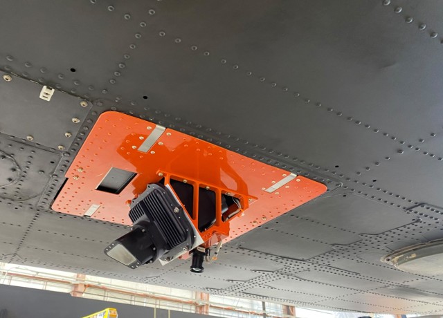
In the test, a camera was affixed to an experimental Black Hawk helicopter to capture terrain images while in flight.
The captured images were then cross-referenced with a map database, allowing the system to provide accurate location data to the pilot when GPS signals were unavailable.

Despite the advanced global positioning systems available to modern Army pilots, relying solely on GPS can present challenges in specific scenarios, especially when confronted with near-peer threats operating within the electromagnetic spectrum domain.
While GPS technology provides valuable navigation capabilities, its vulnerability to interference or jamming calls for additional measures to ensure reliable positioning.
In response to this concern, the Army Futures Command has prioritized Assured Positioning, Navigation, and Timing (PNT) to tackle the challenges associated with reliance on GPS. Visual Based Navigation (VBN) development has emerged as a highly valuable solution within this framework.
In a statement, AvMC Navigation Technical Area Lead Dr. Greg Reynolds said, “The test was a win for one of Army Futures Command’s top modernization priorities — Assured Positioning, Navigation, and Timing, which looks for solutions to combat near-peer threats operating in the electromagnetic spectrum domain.
“But also important to note the technology, developed by industry partners at Leidos, is “100% government-owned.”
He praised the teamwork of AvMC’s Rotorcraft In-Flight Labs, Flight Test Division, Missiles Navigation Technology Division, and the Program Executive Office Aviation’s PM Assured Airspace Access Systems. Together, they played a crucial role in successfully developing Visual Based Navigation during the test.
After the experiment, the camera technology remained attached to the aircraft for subsequent flights in a ride-along capacity. This unplanned opportunity resulted in additional data collection, which proved invaluable in refining the algorithm and further enhancing the system’s accuracy.
USA’s Quest For Dependable Navigation Solutions Beyond GPS
While the Global Positioning System (GPS) satellites continue to serve as the primary source of positioning, navigation, and timing for the military, their vulnerabilities are becoming increasingly apparent as adversaries develop capabilities to disrupt or undermine the GPS signal.
This poses a significant challenge for the military, as ensuring the ability of warfighters to verify and replace such data in degraded or denied environments becomes crucial.
Identifying this problem, the Army has prioritized finding solutions to deliver capabilities that address these challenges, allowing soldiers to operate effectively in situations where GPS reliability is compromised.
The Army is actively engaged in various projects to develop alternative navigation systems to counter the challenges posed by contested environments affecting GPS reliability.
One notable example is the US Air Force’s recent achievement in implementing real-time magnetic navigation (MagNav) during a flight on the C-17A Globemaster III, as reported by The EurAsian Times in late May.

Similarly, Vision-aided navigation is pivotal in the Army’s comprehensive objective of delivering uninterrupted Positioning, Navigation, and Timing (PNT) capabilities to its soldiers.
The technology offers crucial benefits in crewed missions by drastically reducing crew workload. It eliminates the need to manually track the aircraft’s route on a map using nearby terrain features, streamlining operations and enhancing efficiency.
Furthermore, VBN also holds immense potential for unmanned missions and the advancement of full-scale autonomy.
In unmanned scenarios, where the risk of GPS signal loss looms, the position-aiding capabilities of VBN become critical in ensuring the secure and efficient execution of missions.
This technology offers a vital backup system that enables unmanned aircraft to retain their position precisely and accomplish their objectives before returning safely to friendly lines.
Therefore, the service believes that the implications of this system are vast, potentially revolutionizing how unmanned systems operate and paving the way for advanced autonomous missions in challenging environments.
- Contact the author at ashishmichel(at)gmail.com
- Follow EurAsian Times on Google News


