
OPED By Lt Gen. PR Shankar
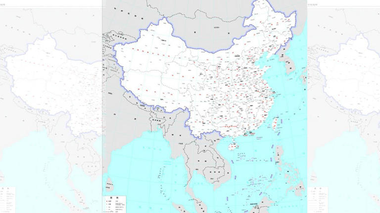
The “New Standard” political map released recently by China shows Aksai Chin, Arunachal Pradesh, Taiwan, and the area enclosed by an extended Nine Dash Line as its integral part.
The difference between China’s old position and the new one is that areas that were hitherto part of its territorial claims are now being shown sovereignty to it. It has specific direct implications.
Implications Of The New Standard Map
Firstly, any action taken by China in these areas is legally interpreted. Secondly, using force in these areas will be justified as it amounts to defending/regaining Chinese sovereign territory.
Thirdly, it is a “lawfare based on the fabricated history” toolkit of the Chinese three warfare strategy. Fourthly, it sets the stage for it to take action by force against India or Taiwan at a time of its choosing.
Fifthly, Chinese laws will be applicable in these areas, and those who are in these areas/pass through these areas will be deemed to be under the jurisdiction of Chinese law.
China now sees the South China Sea as its own. It has international ramifications since considerable trade passes through this area.
In releasing this expanded political map, China has thrown the gauntlet down to those against or affected by its expansionism. It also underlines the Chinese intent to ignore the international rules-based order and supplant it with a Sino-centric order.
However, nothing has changed except in the South China Sea, where trouble can be expected from Chinese maritime aggression or posturing.
As far as India is concerned, the message is unmistakable. China will not negotiate on the LAC. To expect China to even agree to the status quo ante of 2020 along the LAC is wishful thinking hereafter.

In the short term, India has to find new ways to leverage China out of Depsang and Demchok. In a long time, India must find a new modus vivendi to handle the more significant issue of the LAC and retaking Aksai Chin.
Based on its new cartographic assertion, India must expect China to be more militarily aggressive along the LAC. China has permanently elevated itself from being a competitor to being an adversary.
Events prove that the late George Fernandes, India’s Minister of Defense under Prime Minister Atal Bihari Vajpayee, was prophetic when he declared China India’s Number 1 enemy.
In this context, it is relevant to examine issues that put the whole Chinese fabrication in its correct framework so that necessary action can be taken.
Report To US Congressional Commission On China
On June 23, 2022, the findings of a project report were presented at the US Congressional-Executive Commission on China. As per this report, pre-1949 official historical records completely discredited the Chinese version of its territorial claims.
The report concludes that Tibet was never a part of China before the People’s Republic of China (PRC) invaded it in 1950. Maps from the Ming and Qing dynasties prove Tibet was never part of any Chinese empire.
The PRC’s claims to Tibet are baseless. Its version of ‘Chinese history’ differs significantly from the actual ‘Chinese history.’ From historical records, Tibet is an occupied territory. This focuses on the India-Tibet-China triangle and the Sino-Indian border issues at play.
With the publication of this new map with fabricated borders, there is reason for India to review its stand thoroughly. It is, therefore, necessary to step back into history and relook at the issues involved from different perspectives.
Chinese Historical Perspective
Historically, the outer frontiers of Imperial China were defined by the ‘Great Wall.’ It was built to keep outsiders at bay and protect the Silk Road from marauders descending from Tibet and Mongolia. The Great Wall defines the outer limits of China’s boundaries.


However, there is no ‘Single’ Great Wall of China. A series of Walls was raised by different dynasties depending on the extent of their empire and what they considered China.
Considering all the “Walls,” only the areas within these walls are part of China. Mutatis mutandis, anything outside, is not China, and that includes Tibet.
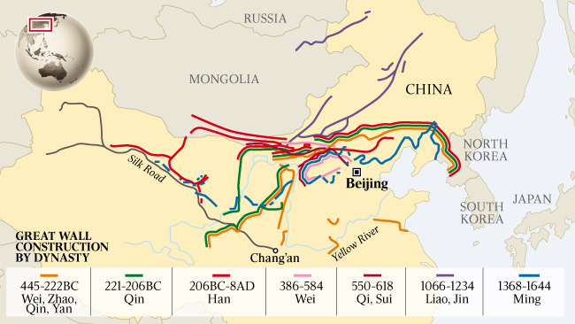

From this fundamental logic, it is pretty clear that there is only ‘One China,’ the area encompassed by the Great Wall to the North and the coastline to the South. The regions of Tibet, Xinjiang, and Taiwan are well outside the ‘One China’ based on historical evidence.
Until 1932, Tibet, Xinjiang (Sinkiang), Manchuria, Mongolia, and Taiwan were not part of China. This is borne out by a US map of those times (see below).
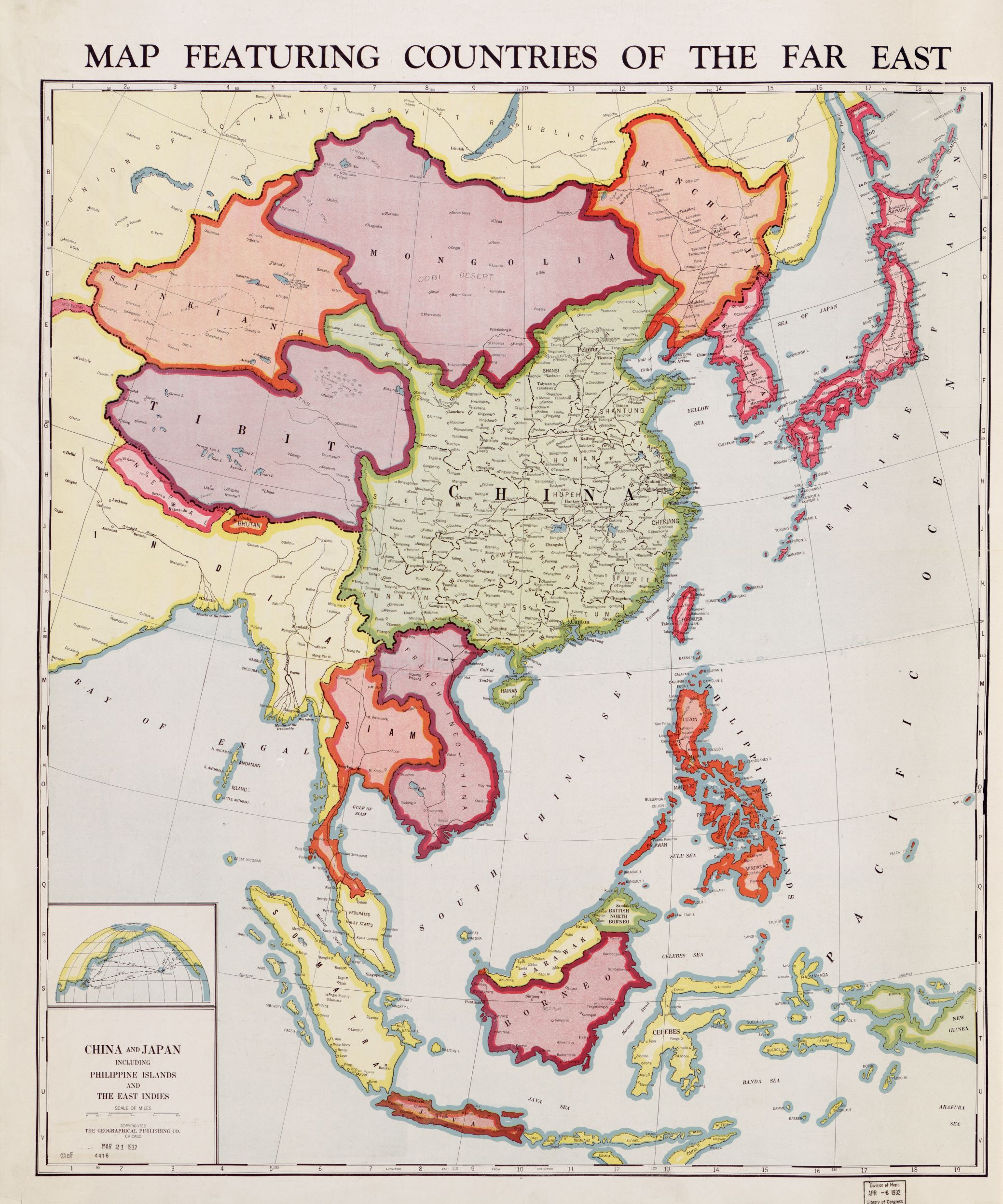

Xinjiang, Manchuria, and Mongolia were assimilated into China during a politically turbulent period that spanned the Japanese occupation, the civil war, and the end of the Second World War. Tibet was invaded in 1950 and annexed entirely in 1956.
Tibetan Perspective
As per Tibetan history, Songtsen Gampo (627-649) ruled Tibet as an independent kingdom in the 7th century. He married a Chinese princess to establish relations with China.
Buddhism also entered Tibet from India around that time. Tibet remained independent till the Mongols conquered and ruled China and Tibet in the 13th century. When Mongols waned, the succeeding Ming dynasty (1368-1644) did not take over Tibet.
The following (and last) imperial Qing dynasty (1644-1911) were Manchus. In 1720, political turmoil in Tibet enabled Manchus to intervene and restore order in Tibet.
After that, their Resident in Lhasa exercised control till their dynasty collapsed. All this while, Tibet retained its own official and legal system. The Qing did not attempt to formalize Tibet as a Chinese province. This nebulous relationship was termed as ‘Chinese Suzerainty’ by the Britishers.
In 1904, when Col. Younghusband’s expedition entered Lhasa, Chinese influence waned. Chiang Kai Shek’s Nationalist Government declared Tibet part of China in 1912.
Immediately, in February 1913, the 13th Dalai Lama declared the independence of Tibet and expelled all Chinese. This created a de-facto-independent Tibet with its flag, army, government, language, currency, and border control.
The British presence forced the Chinese out of the area. As the British power waned after India’s independence, the Communist Party of China, in 1949, instigated the Panchen Lama to appeal to them to liberate Tibet.
In 1950, the PLA invaded Tibet through this ruse, and the rest is history. The long and short of it is that Tibet was forced to amalgamate into China. It was never an integral or sovereign part of China, as often claimed by the PRC.
The relationship between Tibet and China was of only suzerainty periodically. The Report to the US Congressional Committee now buttresses all this.
Indian Perspective
Tibet was not recognized as part of China till the 2003 agreement was reached. The 2003 agreement reads, “The Indian side agrees to designate Changgu of Sikkim state as the venue for border trade market; the Chinese side agrees to designate Renqinggang of the Tibet Autonomous Region as the venue for the border trade market.”
Only this paraphrasing establishes recognition of Tibet as part of China and Sikkim as part of India. Nathu La pass is mentioned as an entry and exit point and is treated as the border by common understanding.
In 2003, China never contended that the Tibet Autonomous Region extended South of the MacMahon Line. The common understanding was that Tibet was generally North of the MacMahon Line, even if it was in dispute at some places.
This is borne out by a postage map of China of 1917 vintage, which indicates that Arunachal Pradesh was never part of Tibet. Also, the alignment of the Northern Boundary is more or less along the traditional concept. Also, Tibet, Xinjiang, and Mongolia are shown as separate parts.


Chinese claims on Arunachal Pradesh as South Tibet started after 2003. It was in 2006 that China came out with a map on its Water Ministry Website (now removed) wherein it laid its cartographic claim on Arunachal as South Tibet.
In claiming so, the Chinese violated their commitments of 2003. Further, China has violated all Sino-Indian agreements in their 2020 aggression in Eastern Ladakh. Given just these facts, it is perfectly legal that India does not recognize Tibet as part of China.
Sakteng Gambit
In 2020, China claimed the Sakteng Sanctuary, 100 km deep into Bhutan. This area is contiguous to the Tawang Tract. The Chinese have now started claiming this area as part of South Tibet.
The Chinese have simultaneously revived Mao’s palm and five fingers theory, which says, “Xizang (Tibet) is China’s right hand’s palm, which is detached from its five fingers — of Ladakh, Nepal, Sikkim, Bhutan and Arunachal. As all of these five are either occupied by, or under the influence of India, it is China’s responsibility to ‘liberate’ the five to be re-joined with Xizang (Tibet)”.
With the publication of this new standard map, which does not include Sakteng, it must be noted that China has virtually renounced its claims to this part of Bhutanese territory. Further, Mao’s Five Finger theory stands debased.
One China
The ‘One China’ principle is a core issue by which the PRC claims Taiwan. By extension, this principle gives legitimacy to all areas it has usurped and all other territories it now claims. However, the ‘One China’ principle is based on false premises and deceitful distortion of history done in a typical Communist fashion.
In the 17th Century, Taiwan was a Dutch colony. After a brief period of independence, it was taken over by Imperial China. Later, it became a Japanese colony (1895 to 1952). Japan ceded sovereignty over Taiwan as per the Treaty of San Francisco and the Treaty of Taipei on April 28, 1952, to the Republic of China (ROC) and not to the PRC (CCP).
Ever since then, Taiwan has been an independent state. It has never been ruled by the Communists, even for a day. Till the mid-70s, many governments did not recognize the PRC.
Most governments recognized and dealt with the ROC. Only when the United States recognized the PRC in 1979 did the very idea and concept of the ‘One China’ principle come into being.
As per this, the PRC insists Taiwan is an unalienable breakaway part of its territory. PRC wants to annex it by force if necessary. This has been one of the critical themes even in the recent 20th Party Congress of the PRC. From all perspectives, the ‘One China’ principle is a recent-day construct and is not based on historical evidence.
Nine Dash Line
China twisted and manufactured history using the Nine Dash Line to lay claim to the entire South China Sea. Not paying heed to Chinese expansionist intent and not contending its falsehoods emboldened the PRC to establish artificial islands in the South China Sea and control part of it.
In the new ‘Standard Map,’ China has extended the Nine Dash line to cover Taiwan and the seas around it. Further, the Senkaku Islands, disputed with Japan, have also been encompassed.
China has converted its claim into sovereign territory over most of the South China Sea. It will now start laying sight to claim and control the balance of the South China Sea.
Conclusion
When all these historical perspectives are viewed along with shifting Chinese stances, the hegemonistic designs and ambitions of the PRC stand thoroughly exposed. Overall, specific facts emerge.
Tibet is legally not part of China. Further, Tibet, which India recognized in 2003, is now in dispute due to additional claims into Arunachal Pradesh and violating all agreements during their 2020 aggression in Eastern Ladakh.
Hence, there is a legal and justifiable case for India to change its position and negotiating stance with the Chinese. Also, their map rendered the Chinese claims on Bhutanese territory invalid.
This aspect must be reinforced and ensured that the Bhutanese do not budge. Also, there is a pressing case for India to take the lead in forming a group of nations to restore territory/maritime rights that have been usurped/impeded by China.
The ball is now in India’s court. It must be played in the forthcoming ASEAN forum, G20 meet, or through direct negotiations with the Chinese. Mere protests and condemnation of the Chinese stance will not help.
- Lt. Gen. PR Shankar retired as the Director General of Artillery of the Indian Army and has vast operational experience along the Line of Actual Control with China and the Line of Control with Pakistan. He is an alumnus of Defence Services Staff College, Wellington; Army War College, Mhow; Naval Post Graduate School, Monterrey; and National Defence College, Delhi. He tweets @palepurshankar
- Follow EurAsian Times on Google News


