There appeared to be a thaw in ties between China and the Philippines after a PLA Navy warship made a friendly port call in Manila. However, with the Philippines now welcoming tourists to the disputed Spratly Islands, that could almost be expected to change.
The Spratly Islands comprise over 100 tiny islets and reefs encircled by abundant fishing grounds and perhaps gas and oil resources. China, Taiwan, and Vietnam each claim the entire group of islands, while Malaysia and the Philippines each claim a section of them.
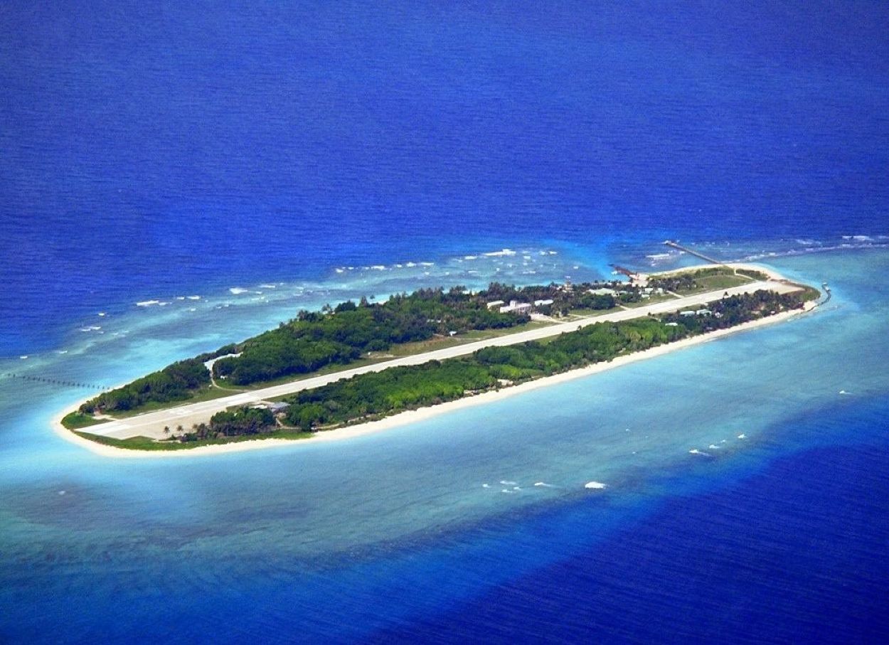
The islands the Philippines claims are located in the northeastern Spratly archipelago, which locals call the ‘Kalayaan Island Group’ of the West Philippine Sea. This is where Manila has seized the opportunity to bolster its claims by opening the disputed islet to tourism.
The Great Kalayaan or Freedom Expedition is a seven-day excursion onboard a dive yacht, with an average price per participant of around US$2,000. “The Great Kalayaan Expedition aims to open the vast West Philippine Sea for tourism,” tour organizer Ken Hupanda told Channel News Asia.
This first paid trip saw a Chinese Coast Guard ship and other Chinese-owned vessels, giving the tour participants a first-hand view of China’s maritime might, something they weren’t expecting.
Later, Chief Engineer Wilfredo Baladjay of the yacht received an automated message from a Philippine telecom company welcoming him to China as they anchored at Philippine-controlled Thitu, also known locally as Pagasa or Hope Island.
Almost frustrated by the continuous Chinese presence and assertiveness, Baladjay said, “I cannot accept why the island’s connection is with China. (Pagasa) is the Philippines. Why did it become China?” Meanwhile, the Philippine Navy force stationed in Thitu continuously pressed the Chinese ship to leave the area.
While the incident may have felt unsettling to these first-time tourists, the engagements between the Philippines and Chinese coast guard vessels are not uncommon. The Philippines Coast Guard (PCG) has reported several incidents of intimidation by their Chinese peers.
China Navy Training Ship Visits The Philippines
The Chinese navy training ship made a port call in the Philippines on Wednesday, its final stop on a goodwill tour of four countries as Beijing looks to mend fences in the region.
"It's a goodwill visit," Chinese ambassador to the… pic.twitter.com/EXX86XSylM
— Zhang Meifang (@CGMeifangZhang) June 15, 2023
However, the recent Chinese navy training ship’s port call in the Philippines on June 14, its last stop in a goodwill tour of four countries, signaled a thaw in ties as Beijing seeks to mend its broken relationships with Southeast Asian countries dramatically shifting towards the US.
Tensions between China and the Philippines have been running high this year, with the latter granting the US access to four more of its military bases under an Enhanced Defense Cooperation Agreement (EDCA) signed in 2014. Beijing’s ambassador to Manila said the country was “stoking the fire” of regional tensions.
Manila’s decision to use tourism to bolster its hold on the claimed part of the Spratly Islands may not go down well with Beijing. “Although the program’s aim is not exactly to create an aggressive move, we believe that it gives some value to our claim (of the Kalayaan Islands),” the tour organizer told the media.
Additionally, the Philippines’ Defense Secretary Delfin Lorenzana said the government might allow hotels for tourists on the tiny Thitu Island. By the end of the year, the military hopes to upgrade the islet’s runway. Later, buildings for the troops and “possibly some hotels for Filipinos who would like to go there as tourists” will be constructed.
Although building hotels on one’s territory sounds harmless, Manila would be up against a much more powerful adversary when it decides to do so. For perspective, several Chinese vessels have encircled Thitu over the years, causing anxiety in the region before leaving and returning to the open ocean.
History is full of incidents where opening a disputed or un-demarcated region to tourists and expeditions triggered full-blown military conflicts. One such incident happened several decades ago between the two South Asian rivals- India and Pakistan – in the very high-altitude region of Siachen.
When Pakistan Opened Siachen To Mountain Expedition
It started with an ambiguous or undefined border, as with many protracted confrontations.
Years after India and Pakistan fought a war in 1971, resulting in Bangladesh’s liberation, an Indian army colonel and in-charge of the Indian Army’s mountain warfare school, Narendra Kumar, was shown an uncanny US-drawn map of northern Kashmir in the late 1970s by a German mountaineer.
Incidentally, this map marked the Indian-Pakistan ceasefire line farther east than he had originally anticipated, as per Indian perception. The map seemed to show that the Siachen glacier and a sizable portion of the eastern Karakoram had been cartographically given to Pakistan by the Americans.
Despite multiple ceasefire agreements, India and Pakistan never formally defined the “line of control” in the far northern region of Kashmir, including the Siachen. Additionally, each side kept producing a different map illustrating its interpretation of the landscape.
However, Pakistan was the first to recognize the possibility of filling the strategic void. It even allowed international mountaineers to circumnavigate the glacier with permission throughout the 1970s, giving the impression that this was Pakistani territory.
Soon after, an Indian Army team organized an expedition to the glacier, and the word spread across the border. When this team reached Siachen, Pakistani helicopters flew overhead and fired colored smoke, as per anecdotes shared by Col Kumar.
By this time, the team was convinced that Pakistan was taking over the territory, and some trash found by the Indian troops belonging to previous climbers further aided that perception. Soon after, the Indian Army mapped the entire glacier and published its claims in a famous mountaineering magazine.
The Pakistani Army was determined to entrench their claim and decided to go and set base. However, aided by Indian intelligence, Indian Army troops were sent at least a week before Pakistan’s.
The conflict was started in 1984 by India’s successful capture of the Siachen Glacier as part of Operation Meghdoot, followed by Operation Rajiv in 1987.
India took control of the 70-kilometer-long (43 miles) Siachen Glacier and its tributary glaciers, as well as all the main passes and heights of the Saltoro Ridge immediately west of the glacier, including Sia La, Bilafond La, and Gyong La. Pakistan controlled the glacial valleys immediately west of Saltoro Ridge.
A ceasefire agreement was eventually finalized in 2003. However, to this day, both sides maintain a heavy military presence in the area. The discovery of mountaineering expeditions for tourists by one side eventually led to a big blow and militarization of Siachen that continues today.
- Contact the author at sakshi.tiwari9555(at)gmail.com
- Follow EurAsian Times on Google News


